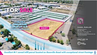
Roseville Rd @ Stationers Way - Commercial LAND FOR SALE
Sacramento, CA 95842- Outer Carmichael/Citrus Heights | 53,143 SF
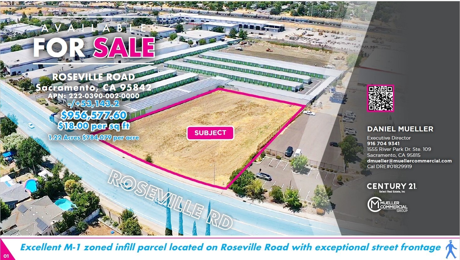
$956,578 USD

916-704-9341
Roseville Rd @ Stationers Way
Sacramento, CA 95842
Outer Carmichael/Citrus Heights
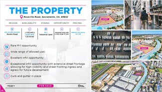
OVERVIEW
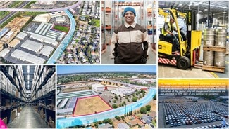
A commercial and industrial corridor like Roseville Road, with its blend of business and manufacturing zones, offers a unique set of advantages. The presence of commercial density, with retail, offices, and services clustered together, creates a synergistic environment. This proximity allows businesses to benefit from shared customer traffic, as consumers often combine multiple errands into a single trip. A hardware store, for example, might see increased foot traffic from customers who have just visited a nearby home improvement store or a paint shop. This density also makes the area a more attractive location for new businesses, as they can tap into an existing customer base and benefit from the established commercial ecosystem.
The inclusion of industrial density, particularly with M-1 zoning, further enhances this symbiotic relationship. M-1 (Light Industrial) zones are designed to accommodate a wide range of uses, from manufacturing and warehousing to research and development and wholesale businesses. The close proximity of M-1 zones to commercial areas is highly beneficial. For example, a retail store in a commercial zone could easily receive supplies from a nearby warehouse in an M-1 zone, reducing transportation costs and delivery times. Similarly, a technology firm in a commercial office building could have its prototyping or manufacturing facilities just down the road in an M-1 zoned property, streamlining their operations.
A business operating on an M-1 zoned piece of land within this corridor stands to benefit significantly. The M-1 designation provides flexibility, allowing for a mix of uses that might not be permitted in other zones. This could include a manufacturer that also has a small showroom to sell its products directly to the public, or a company that combines its corporate headquarters with its warehousing and distribution center. The M-1 zoning also often allows for higher building heights and fewer restrictions on loading and storage, which are crucial for industrial operations. The overall combination of commercial and industrial density creates a robust economic engine, where businesses support each other, and the entire corridor becomes a hub for both goods and services, attracting a diverse workforce and fostering sustained economic growth.
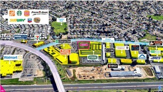
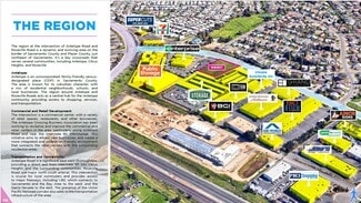
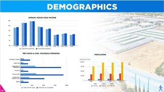
The region at the intersection of Antelope Road and Roseville Road is a dynamic and evolving area on the border of Sacramento County and Placer County, just northeast of Sacramento. It's a key crossroads that serves several communities, including Antelope, Citrus Heights, and Roseville.
Antelope:
Antelope is an unincorporated, family-friendly census-designated place (CDP) in Sacramento County. The area is known for its suburban character, with a mix of residential neighborhoods, schools, and local businesses. The region around Antelope and Roseville Roads acts as a central hub for the Antelope community, providing access to shopping, services, and transportation.
Commercial and Retail Development:
The intersection is a commercial center, with a variety of retail spaces, restaurants, and other businesses. The Antelope Crossing Business Association has been working to revitalize and improve the commercial and retail centers in the area, particularly along Antelope Road and near the Interstate 80 interchange. This initiative aims to attract new businesses and create a more integrated and pedestrian-friendly environment that connects the retail centers with the surrounding residential areas.
Transportation and Connectivity:
Antelope Road is a significant east-west thoroughfare, providing a direct exit from Interstate 80 into Citrus Heights and the surrounding communities. Roseville Road is a major north-south arterial. This intersection is crucial for local commuters and provides access to major freeways, including I-80, which connects to Sacramento and the Bay Area to the west, and the Sierra Nevada to the east. The presence of the Union Pacific Railroad corridor also adds to the transportation infrastructure of the area.
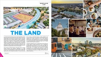
Planning and Future Development:
The region is a focus of ongoing planning and development efforts. Specific plans, such as the East Antelope Specific Plan and the Antelope Station Special Planning Area, aim to guide future growth in an orderly manner. These plans often focus on creating mixed-use developments that are supportive of public transit, walking, and biking, with the goal of reducing reliance on automobiles and improving the overall quality of life. Future projects may include the development of new shopping centers, office spaces, and residential areas.
FOR SALE DETAILS
PRICE
$956,578 USD
PRICE/ACRE
$784,080/AC
PRICE/SF
$18 USD /SF
# OF LOTS
-
LAND DETAILS
PROPERTY NAME
Vacant Land
PROPERTY TYPE
Land
PROPERTY SUBTYPE
Commercial
LAND PROPOSED USE
Industrial
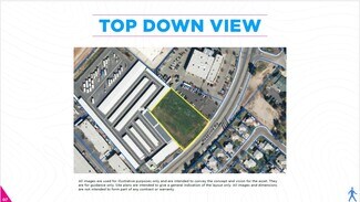
LAND ACRES
1.22 AC
LAND SF
53,143 SF
OFFSITE IMPROVEMENTS
Sewer, Water, Electricity, Gas, Streets, Curb/Gutter/Sidewalk, Cable, Telephone, Irrigation
ZONING
M-1
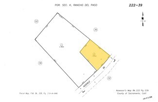
APN/PARCEL ID
222-0390-002
ASK ABOUT THIS PROPERTY
Please correct the highlighted field(s).

916-704-9341
By clicking the button, you agree to Showcase's Terms of Use and Privacy Notice.
Please correct the highlighted field(s).
916-704-9341
By clicking the button, you agree to Showcase's Terms of Use and Privacy Notice.