629 Fifth Ave - Office For Rent
Pelham, NY 10803 | 966-1,350 SF

914-421-0444

629 Fifth Ave
Pelham, NY 10803
OVERVIEW
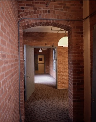
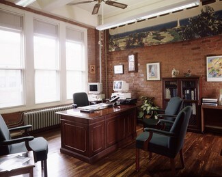
The Sanborn Map building is rich in history. It was built in 1905 by The Sanborn Map Company, one of the largest and oldest map companies in the country. During the second World War, the building was under constant surveillance by the F.B.I. due to the highly classified allied invasion maps that were stored there. The Sanborn Map Company still occupies a major portion of the buildings first floor.
The Sanborn Map building is classic both inside and out. It is situated on a beautiful 5 acre parcel in a secure and upscale residential area of Pelham, NY with proximity to major areas of commerce. The expansive brick building houses 75,000 sq. ft. spread out over three floors. The
The Sanborn Map building has a prime location in Westchester County, New York. Directly off the Hutchinson River Parkway, there is easy access from all major thoroughfares including the New England Thruway and the Cross Westchester Expressway as well as the Bronx River, Sprain Brook and Saw Mill River Parkways. The Metro North train station is just 3 short blocks away offering access from New York City in only 30 minutes.* Efficient floor plates with ready-built units ranging from 1,000-10,000 sf
*Unparalleled NYC access via the Pelham Metro North train station and major highways.
*Close proximity to restaurants, shops and banks in downtown Pelham
*Outdoor courtyard with seating and space for events
*Cablevision, Verizon Fios service and T1 lines in the building via fiber optics communications network
*Free on-site parking
* Closed circuit security camera system monitoring the property
*Creative and flexible ownership
RENTAL DETAILS
SPACE AVAILABLE
966-1,350 SF
# OF SPACES
2
RENT RATE (MO)
$1.92 USD /SF/mo
RENT RATE (YR)
$23.00 USD /SF/yr
LEASE TYPE
Modified Gross, Plus Electric
LEASE LENGTH
5-10 Years
AVAILABLE
Now
BUILDING DETAILS
PROPERTY TYPE
Office
ADD'L SUBTYPES
Loft/Creative Space
TOTAL BUILDING SIZE
75,000 SF
BUILDING CLASS
B
YEAR BUILT
1905
PARKING SPACES
28
LAND DETAILS
LAND ACRES
5 AC
LAND SF
217,800 SF
ZONING
OFF1
ASK ABOUT THIS PROPERTY
Please correct the highlighted field(s).

914-421-0444
By clicking the button, you agree to Showcase's Terms of Use and Privacy Notice.
Please correct the highlighted field(s).
914-421-0444
By clicking the button, you agree to Showcase's Terms of Use and Privacy Notice.