43856 Granite Hill Hwy - Commercial LAND FOR SALE
Sumpter, OR 97877 |
43856 Granite Hill Hwy
Sumpter, OR 97877
OVERVIEW
The Ibex-Bald Mountain gold-silver vein system is located in the Blue Mountains of northeastern Oregon. The mineralization occurs in northeast-striking, steeply dipping fissure veins, hosted by the Elkhorn Ridge argillite within several miles of the Bald Mountain batholith. The vein material consists of gouge, quartz argillite breccia and quartz veined argillite. Mineralization consists of visible gold and electrum, tetrahedrite (freibergite), pyrargyrite, pyrite, and other minor silver minerals.
A major underground and surface exploration drilling program with expenditures in the order of US$9 million was carried out on the Ibex-Bald Mountain vein systems over a period of 9 years from 1980 to 1989.
Mineralogical studies, metallurgical tests, mine feasibility studies, and other engineering projects have been completed.
Gold and silver recoveries are in excess of 90% using standard flotation techniques and moderate grinds. CIP cyanide leaching of the concentrate resulted in overall recoveries of about 85% goldand 64% silver.
The geologic resources are estimated by computerized methods to be 749,100 tons at 0.26 oz/ton gold and 2.31 oz/ton silver, containing approximately 195,000 ounces of gold and 1.73 millionounces of silver. Proven reserves are estimated at 403,000 tons, grading 0.26 oz Au/ton. In-fill drilling could easily boost the mineable reserves to 500,000 tons or 125,000 ounces Au equivalent.
There is good potential to significantly increase the current resource on the Ibex-Bald Mountain Vein. Exploration targets on the property could potentially add 1.4 million tons to the reservebase. To date only portions of the Ibex-Bald Mountain Vein system have been tested over a vertical extent of 1200 ft.
Location
The Ibex-Bald Mountain mines are located in the Cracker Creek mining district, in the heart of the "gold belt of the Blue Mountains" (Lindgren, 1901), in northeastern Oregon. The property is located approximately 7 miles northwest of Sumpter, Oregon, a historic mining town. The Ibex claims are located in Grant County and the rest of the claims are located in adjacent Baker County.
The property lies in T8S and T9S, R36E. The area is divided by the Baker-Grant County line, which coincides with the drainage divide of the John Day and Powder Rivers. Located within the Elkhorn Mountains at elevations ranging from 5600 to 6600 feet, the topography is locally rugged. A network of existing roads on the property provide excellent access.
The Ibex-Bald Mountain property is accessed by traveling thirty seven miles on state Highway 22, west of Baker, to Sumpter and then taking the Sumpter-Granite Highway northwest for 2 Miles. Then take the Bear Canyon road northeast for approximately 6.4 miles to the property. Two other log haulage roads from the Sumpter-Granite Highway provide excellent access to the property.
Ibex Mine has is at an elevation of 1,895 meters, or 6,217 feet. Latitude: 44-48'45'' N Longitude: 118-17'57'' W
The climate is hot and dry during the summer with daytime temperatures reaching 90°F (30°C) but generally cooling to 50°F to 60°F (10°C to 15°C) at night. Winters are generally mild with generally light accumulations of snow at the 6000 foot elevation. The area is forested with a variety of conifers including pine, fir, spruce and tamarak.
Cattle ranching and lumber operations provide the main sources of employment. The timber on the Bald Mountain - Ibex optioned claims were logged from 1991 to 1995 and the timber rights on the owned 14 claims have been sold to a timber company. The claim outlines can be discerned today in satellite photos due to logging.
Abundant year-round water on the patented claims is available from 4 separate drainages. The village of Sumpter has basic services including fuel, restaurants and motel accommodations.
Resource & Reserves
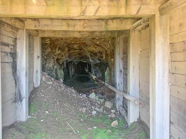
Resource estimates in 1987 by ACNC by computerized methods are 749,100 tons grading 0.26 oz/ton gold and 2.31 oz/ton silver, containing nearly 200,000 ounces of gold and 1,730,000 ounces of silver; proven diluted mineable reserves accessible within existing mine openings were shown to be 197,000 tons grading 0.22 oz/ton gold and 2.95 oz/ton silver. In 2014, the current owners performed work to access to the full extent of over 5000 feet of underground mine workings
Bid Online Only Nov 28 – 30 at auctionnetwork.com
Williams & Williams Worldwide Real Estate, LLC
Philip R. Heiliger LIC. NO. 201211071
5% Buyer's Premium
williamsauction.com/GoldMines
800.801.8003
FOR SALE DETAILS
PRICE
-
# OF LOTS
-
LAND DETAILS
PROPERTY NAME
Oregon Gold Mines Sell Without Reserve
PROPERTY TYPE
Land
PROPERTY SUBTYPE
Commercial
LAND PROPOSED USE
-
LAND ACRES
-
LAND SF
-
OFFSITE IMPROVEMENTS
-
ZONING
-
APN/PARCEL ID
-


