19720 US highway 27 - Industrial LAND FOR SALE
Clermont, FL 34715 | 195,584 SF
$2,750,000 USD
954-214-6700

19720 US highway 27
Clermont, FL 34715
HIGHLIGHTS
- Self-storage confirmed as an allowable use under current MP zoning per Lake County determination — no rezoning required
- 50-ft maximum building height supports three- to four-story climate-controlled development
- ±777 ft of continuous US-27 frontage with Florida Turnpike exposure to the rear
- On-site stormwater retention in place on Parcel 6 — eliminates off-site drainage cost
- ±124,500 combined AADT (US-27 + Florida Turnpike) — minutes to Clermont & Minneola retail
- Seller financing available | Buyer's broker cooperation: 2% at closing, registration required
OVERVIEW
Two contiguous MP-zoned parcels totaling ±4.46 acres on US Highway 27, offering ±777 feet of continuous highway frontage with Florida Turnpike exposure to the rear. Combined daily traffic exceeds 124,000 vehicles. Positioned between Clermont and Minneola with direct connectivity to the Orlando MSA and The Villages, in one of Central Florida's fastest-growing corridors.
Zoning and Use
Both parcels carry MP (Planned Industrial) zoning. Per Lake County Zoning Conformance Letter dated September 2, 2026 (AK 1210658), self-storage / mini-warehouse is included within the Light Industrial use definition under the Lake County Land Development Regulations. No rezoning is required or contemplated. A parallel conformance letter on Parcel 5 (AK 1210691) is pending. This is a use determination and not a site-specific development approval.
Development Standards
Per the same letter, existing development standards are front, rear and side setbacks of 50 feet, in each case measured from all roads or rights-of-way easements bounding the project area, and a maximum building height of 50 feet. The 50-foot height allowance supports multi-story development of three to four levels — a meaningful advantage for climate-controlled self-storage, where vertical build recovers footprint and improves rentable square footage per acre.
Under the Lake County Land Development Regulations, MP districts are established individually under an approved site plan with conditions, meaning site-specific standards are governed by the applicable planned-development ordinance and approved site plan rather than a fixed district table.
The maximum impervious surface ratio is not stated as a single confirmed figure in the County's determination and remains subject to clarification. The Future Land Use category is Urban Low. The County's response addressed only the parcel identified in the application and did not opine on zoning / Future Land Use consistency; the letter expressly does not grant an exception to Comprehensive Plan density requirements and does not guarantee that the property is buildable or has legal access. No representation is made as to buildable area or achievable density; buyer to verify all standards, density and consistency independently.
Site and Configuration
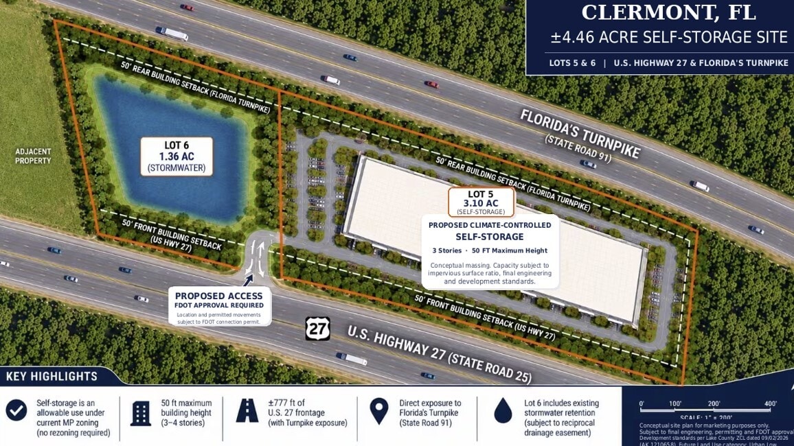
±4.46 acres across two contiguous parcels — Parcel 5, AK 1210691 (3.10 AC) and Parcel 6, AK 1210658 (1.36 AC) — arranged side by side with continuous frontage on US Highway 27 and rear frontage on the Florida Turnpike.
Parcel 5 carries approximately 539 feet of US-27 frontage and Parcel 6 approximately 238 feet, for ±777 feet continuous. Level topography. Utilities at the corridor. Continuous frontage supports monument and pylon signage. Recent survey completed and available on request. All dimensions approximate and subject to survey.
Access
Vehicular access is from US Highway 27 only. The Florida Turnpike provides frontage, exposure and visibility; it does not provide access. Access configuration, curb-cut location and permitted turning movements are subject to an FDOT connection permit determination. No representation is made as to the location, number or movement type of any access connection prior to FDOT permit issuance.
Stormwater — Parcel 6
Parcel 6 contains an existing stormwater retention facility serving the broader ±11.03-acre assemblage under common ownership. The retention area is approximately 0.7 acres within the 1.36-acre parcel per the conceptual site plan, with the balance in upland. Parcel 6 will be conveyed subject to a recorded reciprocal drainage easement reserving capacity to the remaining parcels of the assemblage. The facility eliminates the need for a buyer to construct off-site retention or to surrender developable area on Parcel 5 for on-site drainage. Buyer to independently verify retention area, available capacity and permitted allocation.
Existing Encumbrance
Parcel 5 is subject to an existing outdoor advertising ground lease that produces in-place income. Lease terms and current income are provided in diligence.
Larger Assemblage
Parcels 5 and 6 form part of a ±11.03-acre, six-parcel assemblage under common ownership fronting US Highway 27. Adjoining parcels — including a ±10,000 SF masonry industrial building on a fenced yard, and highway frontage pad sites — are available separately. Parcels may be acquired individually or as a takedown. Inquire for the full assemblage package.
Ideal Uses
Climate-controlled self-storage · contractor yard / industrial outdoor storage (IOS) · equipment rental or storage · building material distribution · small-bay warehouse or flex space · industrial service operations.
Offering Procedure and Broker Registration
Diligence package — survey, Lake County zoning conformance letter, conceptual site plan and parcel data available on request. Cooperating brokers must register their prospect with the seller in writing prior to first contact or site tour; 2% of sale price is paid by seller at closing to the registered broker of record only, and unregistered introductions are not eligible.
Terms
Seller financing available. Contact owner directly.
FOR SALE DETAILS
PRICE
$2,750,000 USD
PRICE/ACRE
$612,472/AC
PRICE/SF
$14 USD /SF
# OF LOTS
-
LAND DETAILS
PROPERTY NAME
±4.49 AC MP Self-Storage Site | US HWY 27
PROPERTY TYPE
Land
PROPERTY SUBTYPE
Industrial
LAND PROPOSED USE
Industrial, Multi-Family, Auto Dealership, Contractor Storage Yard, Distribution, Lumberyard, Outlet Center, Self-Storage, Warehouse
LAND ACRES
4.49 AC
LAND SF
195,584 SF
OFFSITE IMPROVEMENTS
Electricity, Streets, Curb/Gutter/Sidewalk
ZONING
MP ( Planned Industrial )
APN/PARCEL ID
1210658,1210691
ASK ABOUT THIS PROPERTY
Please correct the highlighted field(s).
954-214-6700
By clicking the button, you agree to Showcase's Terms of Use and Privacy Notice.
Please correct the highlighted field(s).
954-214-6700
By clicking the button, you agree to Showcase's Terms of Use and Privacy Notice.